Prevacuation defined
If disaster may come your way, get out early.
Not everyone can do that, but the more people who get out early, the better for everyone, both people who really need help and first responders trying to keep people safe.
If you have somewhere safe to go, to family or friends, go there before an official evacuation is ordered.
That seems like a good idea.
Unfortunately, it’s not simple, but it’s important to think about the option if you can.
Official Evacuation May Come Too Late
Waiting for an official evacuation notice may be too late for you and your people.
Emergency officials have an incentive to maintain calm and order, so they may not call for evacuation until it is absolutely necessary.
Unfortunately, this caused fatal delays in both Paradise which had a good plan and experience but was quickly overrun and in Lee County Florida during a 2022 hurricane.
It’s important for each of us to try to be self responsible, a part of the solution, not another problem for first responders to handle in a crisis. Being self responsible may mean giving yourself more time by leaving at levels 1 or 2, rather than waiting for an official “Go Now!” order.
Once an official evacuation has been ordered, it’s likely best to follow the directions offered by your local emergency management staff via official alerts. Freelancing your own evacuation in the middle of an official action may cause you and your neighbors more problems than it solves. That said, do everything possible to maintain situational awareness no matter what the official notifications say.
Table of Contents of This Post
Help May Not Be Coming
First responders cannot take care of everyone in moments of disaster, not because they don’t want to, there are just so few of them trying to serve so many of us.
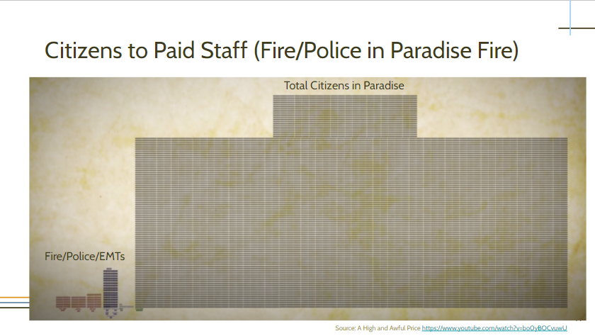
The video explanation of the image above.
And an article from the New York Times about Paradise and the Lahaina fire on Maui: Little warning, few escape routes, phones knocked out: The chilling similarities between the Maui and Paradise fires
It seems obvious, but so many people choose to “risk it.” Do you want your people to be in a situation where only 10% of people are ready to be self-sufficient for the suggested 72 hours? What good could come out of being in such a desperate situation even you and your family are prepared?
If you need to evacuate at the last minute, you are putting yourself into an confused, dangerous situation. We met one woman who drove out of flaming Talent only to be turned around by police because there was fire ahead. She traveled back through the flaming town three times before someone let her through to safety.
It’s probably better to be away from the chaos of an unfolding disaster if you have the option.
If risks are high, consider moving to a safer area early if possible.
Time Is The One Variable You Can Control
Putting distance between you and disaster is a simple formula:
D=RT
Distance from disaster = rate of travel (speed) x time traveled.
If you want to be far away from any disaster, you cannot control when your neighbors leave and create a giant traffic jam.
Here’s the road out of Paradise after the evacuation was ordered.
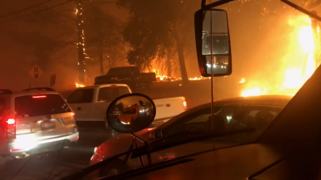
Photo: PBS – You Can Barely Breathe
Leaving early gives you time to travel before traffic gets heavy, before all the hotels are booked, before the danger is upon you. If you are lucky enough to have the option to leave early, you should consider doing so to make things easier for those who must stay until formal evacuation orders are given.
With this in mind, we have used the approach described on this page to make decisions for our family since we moved to the Rogue Valley in 2010.
I have heard of local families who live in particularly fire-prone areas in Southern Oregon who pack up all their valuables and fill a more fire resistant storage unit before every summer just to be safe. That’s extreme, but is based on their own experiences with fire and loss.
You will have to think through what makes sense for your own family and business so you can make timely, fully informed decisions to stay safe.
How To Decide When To Leave?
First, we must be aware of the reality of the situation not only at the moment, but how the situation may evolve over the coming hours and days. We must be aware of the possible situation all along the route we plan to travel, not just in our town.
That said, we must balance the urge to run away against the odds we’re safest at home given the effort, expense, and disruption of evacuation.
But, how to know when the danger is real and avoidable with quick action?
We use the OODA model of situational awareness and action. OODA stands for
- Observe
- Orient
- Decide
- Act
The OODA method requires that we loop through these steps to maintain awareness of the situation as conditions change and our actions may reveal more information to feed into our decision loop.
Here’s an illustration of the OODA loop method.
OODA loops start by observing the world at the very center of the illustration and moving up to the left clockwise to Observe using our senses to collect data.

We make sense of that data by Orienting within mental models we have for understanding the world; weather patterns, road systems, evacuation plans, the behavior of humans and wildfires under certain conditions, etc.
Based on our orientation and evaluation we make a Decision and then Act.
Each action creates a reaction, opens us to new information about the situation, so we then begin a new loop (here the lower one) to observe the world again and continue to orient within our situation to see new options for decisions and actions.
Here’s how we apply this to wildfire risks relative to our family in Southern Oregon.
You can create an online document with links like the ones below to data on the potential risks in your area.
1. Observe – Gather Data
Active fires and warnings
- Fire warnings from the National Weather Service for Southern Oregon are available here.
- Wind direction forecasts can be found on Windfinder.
- Best available, detailed maps, data, and notifications on the current state of wildfires via Watch Duty service/app. Very useful.
- Active Fire Map from oregon.gov
- Current fire and police activity is visible on the Pulse Point app.
- We follow both Jackson County Fire District #5 and Ashland Fire & Rescue.
- Download the PulsePoint app.
- Current fires and the roads they’re near are available on Inciweb.
- Search for Oregon, then change the
- ⚙️ Settings to Roads view. Look for Red flag warnings near you or upwind from you.
Smoke Conditions
AirNow for regular AQI updates and smoke map.
Weather Forecasts
- More detailed weather forecasts are available in the NWS text forecast which will include a fire forecast when there’s a concern

- NOAA forecast zones for reference because the text forecast assumes you know them. Most people in Jackson county live in zone 622, but a serious wildfire threat is likely to come from Zone 623 during strong winds from the East.
- Ashland Fire Department Air Pollution – a bit delayed, but has every-three-hour, six-day forecasts of wind direction and speed. There’s also data that shows the air quality day by day over several years.
Fire Risk Conditions
- Lightning Live – lightning starts many fires in our area, especially when we’re in a drought.
- An indication of the drought level is our lake levels for the Rogue and Jackson county.
- Climate forecast for the coming months
Road Conditions and Traffic
- Trip Check for Oregon road incidents, closures, and cameras
2. Orient
Orient in Space
Maps of
- Your location
- Your risks – active fires, lightning storms, winds, plus your people and animals.
- Your preferred destinations
- Your escape routes
- Risks along the way? See road conditions above.
- Likely to stay open
Orient in Fire Weather
- Extreme fire weather depends on three variables aligning in the region.
- High temperatures
- High winds
- Low humidity
- Meteorologist Cliff Mass shows how strong winds from the east are usually what brings these conditions to Oregon and Washington.
Orient in Time
- Timing of travel under normal conditions
- Time required by your situation – elders, car, pets, livestock, vehicle.
- Congestion timing – how are the roads now? How would an evacuation order affect their flow and the speed of your evacuation? What 5 looked like during the Almeda fire.
- Timing of risks along your escape route – are any of the roads you are planning to use at risk of delays or closure?
3. Decide
- What’s your desired outcome?
- This helps you have a model for evaluating the data and your possible decisions. For instance, what do I value more?
- Keeping my family safe
- Not being a burden on first responders
- Trying to save my house
- Being there for my neighbors
- This helps you have a model for evaluating the data and your possible decisions. For instance, what do I value more?
- Pre-thinking scenarios with decision points and action plans will allow you to use your best thinking in a calm moment rather than trying to think under pressure.
- If this happens, then I will…
- If something worse happens, then I will…
- Cost benefit analysis of avoiding the disaster experience versus being around to help
- How can you really help?
- How might the trauma of experiencing a disaster affect those in your care?
- How can you be best positioned to help your people and community in the days after the disaster and over the years of recovery afterwards?
4. Act
- Whether you decide to go or stay, continue using your OODA loop to remain aware of the situation as it evolves.
- Put your plans into action.
- There’s a lot more on evacuation and response planning for families and small businesses on this page.
- Stay safe and take good care of yourself and your people. Your community needs you safe and healthy.
I hope this is helpful to you and your people. This approach has served us well over the years. It’s a lot, but we considered this extra bit of due diligence a fair price for living safely in our fair valley. Of course, we have professional emergency managers who are real professionals committed to our safety. Sometimes they need to balance concerns across many people while you are responsible for yourself and your people first. Sometimes that can change the timing of evacuation decisions. Given that the stakes are high for our children and parents, we tend to err on the side of caution.
By now, you may think I worry too much.
Some Historical Perspective
In 2021, the city of Ashland paid consultants to prepare an exhaustive evacuation plan based on lots of mathematical analysis.
You can see the evacuation modeling study here. Interestingly, this study assumes that an evacuated person simply needs to get to the edge of the city limits. You can see this in the map of bus routes on page 11-7. The assumption seems to be that everyone would be ready for pickup along the way and that they would be dropped at the city limits where they would be safe and cared for? This certainly would not have been true on the day of the Almeda fire.
According to the report, it would take a minimum 1 hour and 40 minutes to evacuate 90% of one zone (see page 92/7-7 in the report) assuming nearly every household had a vehicle of their own.
But, the Almeda fire traveled 5 miles in two hours, from Ashland to the south edge of Talent. See a great blog post on how the fire traveled here.
We’re very lucky the fire started at the downwind edge of Ashland and not upwind near Emigrant lake or Oak Knoll. The fire would have burned all of Ashland before one zone evacuated.
Plus, in 2020, Highway 5 was closed and all that traffic was diverted into Ashland, so traffic was hugely backed up before an evacuation could even start.
We also have to take into account the definition of evacuation used in the report. It is essentially getting to the edge of Ashland, not away from any threat that went across the border of Ashland to Talent and Phoenix as the Almeda fire did.
Greater mathematical minds than mine did this analysis. But unfortunately, it is based on assumptions that would not have kept you and your family safe if the Almeda fire had started a mile or two further east that day.
And, sadly a fire was intentionally started further east that day. A news article on that fire. Luckily, firefighters rushing to help fight the Almeda fire routed to pass by the fire put it out quickly.
That day another fire intentionally started near Phoenix burned 15 homes.
And, according to Chris Chambers, Ashland Fire’s Division Chief – Forestry, the Almeda fire was not the “big one.” The big one may 300 times larger than the Almeda fire (3,000 acres).
It’s important to understand the reality of human and fire behavior on days of extreme fire danger. Unfortunately, there are many variables to consider when we’re responsible for the safety of our families, colleagues, and neighbors. Lightning and humans are the leading causes of fire and neither are very predictable in terms of time or place, but they are both, unfortunately, inevitable causes of ignition.
And, all of our thinking here assumes you have warning and internet service. In critical moments, you may have neither.
That was the reality for a few people’s escape from the Almeda fire, literally being rescued seconds before the flames destroyed their homes. This body cam footage of the reality of evacuation is not for the faint of heart.
My goal is to help you avoid the trauma and loss of a disaster. I hope our approach to thinking about your people’s safety is helpful.
Be well, be safe,